Posts

Showing posts with the label GIS

Animation with ArcGIS Pro

Image
I collected data from Harris County Flood Control District and USGS for rainfall and stream heights.  I requested data between August 25th and September 5th, 2017 which was the time frame Hurricane Harvey rolled through the area. This animation shows the rainfall accumulation and stream height swell. The streams turn red once the height of the stream went above the top of bank. Here is the full video.

Great Election Maps

Image
We are so used to seeing the geographic map color coded per election results. Did you ever wonder how those colored blue could win when there seems to be so much more red? This is because the geographic map does not accurately depict the real numbers being used. Our elections are not based on the size of the state, nor the population. Elections are won based on the number of Electoral Votes that exist for that State.    Take Montana as an example. It is a large state and is colored red. Compare that with Washington which is blue. Using the map above, a person would see more red than blue, giving the impression that Montana means more than Washington. However, Washington carries twelve (12) Electoral Votes while Montana only carries three (3). This is why we are starting to see Electoral based maps, like the one above. The geometry is altered to fit the Electoral Vote sizes appropriately. Click the links below to view some interactive Electoral based maps.  Do...

Updating GDB_Items XML Definitions

First, run a query to identify the feature class "PhysicalName" or UID from GDB_ITEMS. Note: The physical name appears as DBNAME.SCHEMA.FCNAME. Use one of the two for the WHERE clause in the other queries. First Query USE [DBName] SELECT ITEMS.ObjectID ,ITEMS.UUID ,ITEMTYPES.Name as ItemType ,ITEMS.[PhysicalName] ,ITEMS.[Definition] FROM [sde].[GDB_ITEMS] as ITEMS INNER JOIN [sde].[GDB_ITEMTYPES] ITEMTYPES ON [ITEMS].[ Type ] = [ITEMTYPES].[UUID] WHERE [PhysicalName] like '%FC Name%' In the results, click the XML link under the Definition field. You should see something similar to the XML below. Notice the highlighted line of code. This is the "Remarks" field. The node "IsNullable" is set as "false". I want the Remarks field to allow NULL values and would like to update it from "false" to "true". Note: The base and delta tables should be updated as well. XML Definition View <DEFeatu...

Updated MXDPerfStat

Esri Professional Services just released an updated version of mxdperfstat. A great tool to help you optimize GIS services. Per their documentation the key features include: Performance report for each scale Performance report for each layer including diagnostic statistics Optimization recommendations This update includes the tools that support Esri version 10.4. Updated Mxdperfstat Link

Batch Replace a Layer within multiple MXDs in a Folder

This one is helpful if you have many MXDs located within a folder that need a layer replaced. For those who create Map Books, this could come handy. 1 2 3 4 5 6 7 8 9 10 11 12 13 14 15 16 17 18 19 20 21 22 23 24 25 26 27 28 29 30 31 32 33 34 35 36 37 38 39 40 41 42 43 44 45 46 47 48 49 50 51 52 53 54 55 56 57 58 59 60 61 62 63 64 65 66 67 68 69 70 71 72 73 74 75 76 77 78 79 80 81 82 83 84 85 86 87 88 89 90 91 92 93 94 95 96 97 98 99 100 101 102 103 104 105 106 107 108 109 110 111 # Name: Replace layers in MXD TOC # Purpose: This script is meant to be added to an ArcGIS Toolbox. # It will copy all MXDs within the specified directory to a folder on your desktop. # Then it will scan each MXD in that desktop folder, looking for a layer name, per user input, # and replace with an existing layer file, per user input. # Author: Nicole Ceranek # Date...

Enterprise Geodatabase Maintenance

I have several enterprise level geodatabases (GDB) to manage. Instead of setting up maintenance scripts for each project GDB, I decided to write one script to manage them all. (Get the movie reference?) This script requires two directories to be setup 1) OwnerFileDir and 2) AdminFileDir. The first will store several SDE owner connection files; one per database. Owner is usually "dbo" or "sde". The second will store several Esri object owner connection files; one per database. The Esri object owner is the user that owns each object's schema e.g. < DatabaseName >.< Schema >.< PolygonFeatureClassName >. 1 2 3 4 5 6 7 8 9 10 11 12 13 14 15 16 17 18 19 20 21 22 23 24 25 26 27 28 29 30 31 32 33 34 35 36 37 38 39 40 41 42 43 44 45 46 47 48 49 50 51 52 53 54 55 56 57 58 59 60 61 62 63 64 65 66 67 68 69 70 71 72 73 74 75 76 77 78 79 80 81 82 83 84 85 86 ...

Italy Map Journal

New and Improved Italian Story Map Original Map Journal

Optimize Your MXDs

MXD Perfstat is a great utility to analyze your GIS MXD files. The output contains information such as the number of layers, vertex count per layer per different scales, drawing times, etc. This information is valuable for those who wish to publish data via ArcGIS Online or ArcGIS Server. I used the option to write to a database. Within a database environment I can setup queries, procedures, and eventually charts or reports. Link to download MXD Perfstat

Creating Polygons from Raster Extents

There are many like it, but this one is mine. Catch that reference? OK, so here is a script that will allow the user to select a folder directory. The script will scan the directory for any raster files. It will grab the extents of the raster and build a polygon feature class. When building a mosaic I like to also know the compression type, number of bands, no data value, pixel type, etc. Those options will also be added to the polygon per raster tile. Quick note, I wrote this with the idea that a person could add this script to their toolbox to have a nice GUI interface. The only parameter required is the input file path. 1 2 3 4 5 6 7 8 9 10 11 12 13 14 15 16 17 18 19 20 21 22 23 24 25 26 27 28 29 30 31 32 33 34 35 36 37 38 39 40 41 42 43 44 45 46 47 48 49 50 51 52 53 54 55 56 57 58 59 60 61 62 63 64 65 66 67 68 69 70 71 72 73 74 75 76 77 78 79 80 81 82 83 84 85 86 87 88 89 90 91 92 # Name: Raster Extents to Polygons # Purpose: This script will create a polygon f...

Add Field to a SQL Geodatabase using T-SQL

Image
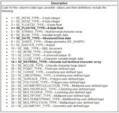
Sometimes a new field will need to be added quickly. The usual process of testing changes and pushing said changes to production is not very time sensitive. Here is a method I use when a new field is needed ASAP. In this case the feature classes have been registered in the geodatabase and archiving has been enabled. This means there is an SDE base table and several SDE delta tables. The information needed to proceed is listed below. This will require DBO level access and SQL Server Management Studio or other suitable RDBMS interface like Toad. Database Name = DemoData New Field Name = NewField New Field Type (Length) = string(50) / nvarchar(50) SDE Field Type Code =   Unknown New Field Name = NewField Feature Class Name = Marker Base Table Name = Marker Base Table ID = Unknown Delta Table (Adds) = Unknown Delta Table (Archive) = Unknown First thing to do is find the unknown values. The SDE Field Type Code via Esri tells us that the SDE Field Type Code for Stri...