Posts

Showing posts with the label geodatabase

Updating GDB_Items XML Definitions

First, run a query to identify the feature class "PhysicalName" or UID from GDB_ITEMS. Note: The physical name appears as DBNAME.SCHEMA.FCNAME. Use one of the two for the WHERE clause in the other queries. First Query USE [DBName] SELECT ITEMS.ObjectID ,ITEMS.UUID ,ITEMTYPES.Name as ItemType ,ITEMS.[PhysicalName] ,ITEMS.[Definition] FROM [sde].[GDB_ITEMS] as ITEMS INNER JOIN [sde].[GDB_ITEMTYPES] ITEMTYPES ON [ITEMS].[ Type ] = [ITEMTYPES].[UUID] WHERE [PhysicalName] like '%FC Name%' In the results, click the XML link under the Definition field. You should see something similar to the XML below. Notice the highlighted line of code. This is the "Remarks" field. The node "IsNullable" is set as "false". I want the Remarks field to allow NULL values and would like to update it from "false" to "true". Note: The base and delta tables should be updated as well. XML Definition View <DEFeatu...
Enterprise Geodatabase Maintenance

I have several enterprise level geodatabases (GDB) to manage. Instead of setting up maintenance scripts for each project GDB, I decided to write one script to manage them all. (Get the movie reference?) This script requires two directories to be setup 1) OwnerFileDir and 2) AdminFileDir. The first will store several SDE owner connection files; one per database. Owner is usually "dbo" or "sde". The second will store several Esri object owner connection files; one per database. The Esri object owner is the user that owns each object's schema e.g. < DatabaseName >.< Schema >.< PolygonFeatureClassName >. 1 2 3 4 5 6 7 8 9 10 11 12 13 14 15 16 17 18 19 20 21 22 23 24 25 26 27 28 29 30 31 32 33 34 35 36 37 38 39 40 41 42 43 44 45 46 47 48 49 50 51 52 53 54 55 56 57 58 59 60 61 62 63 64 65 66 67 68 69 70 71 72 73 74 75 76 77 78 79 80 81 82 83 84 85 86 ...

Add Field to a SQL Geodatabase using T-SQL

Image
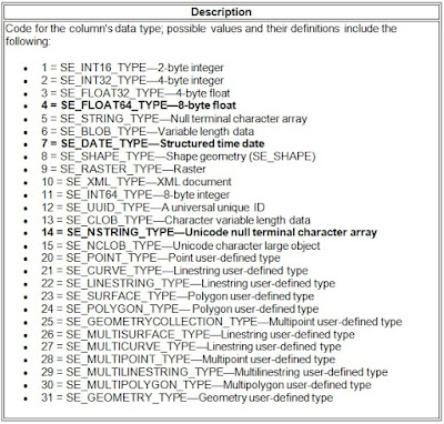
Sometimes a new field will need to be added quickly. The usual process of testing changes and pushing said changes to production is not very time sensitive. Here is a method I use when a new field is needed ASAP. In this case the feature classes have been registered in the geodatabase and archiving has been enabled. This means there is an SDE base table and several SDE delta tables. The information needed to proceed is listed below. This will require DBO level access and SQL Server Management Studio or other suitable RDBMS interface like Toad. Database Name = DemoData New Field Name = NewField New Field Type (Length) = string(50) / nvarchar(50) SDE Field Type Code =   Unknown New Field Name = NewField Feature Class Name = Marker Base Table Name = Marker Base Table ID = Unknown Delta Table (Adds) = Unknown Delta Table (Archive) = Unknown First thing to do is find the unknown values. The SDE Field Type Code via Esri tells us that the SDE Field Type Code for Stri...